|
The
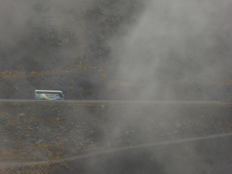
Carretera del Diablo
(translated as Devil’s Highway)
is a famously treacherous and winding road in
Peru that offers
spectacular views but also challenges for those who attempt to travel
it. It is located in the Andes
Mountains, connecting
Cusco to Puno.
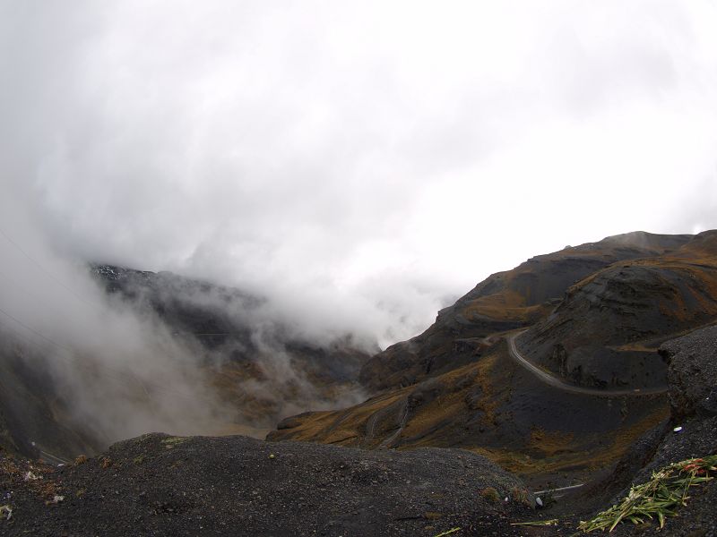
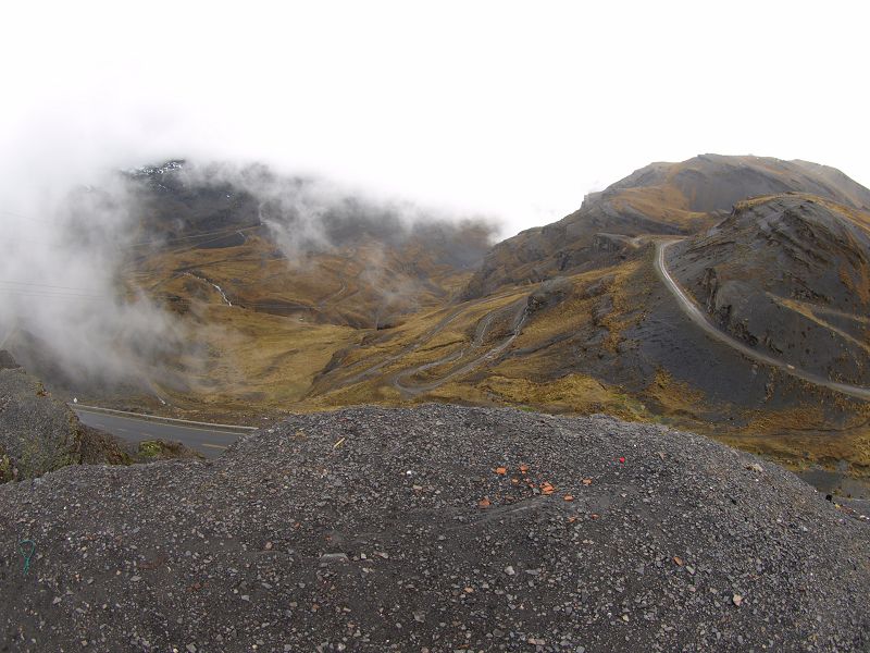
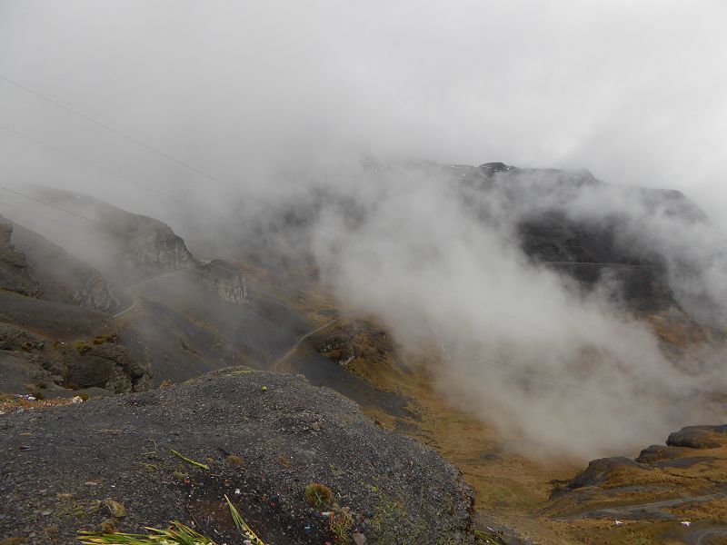
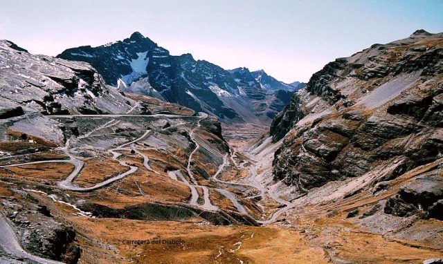
The road is known for its extreme twists, sharp curves, and
high-altitude sections, making it an adventure for those brave enough to
drive or travel along it.
Key Features of the Carretera
del Diablo:
-
Location:
- The
Carretera del Diablo
runs through the highlands of southern Peru, specifically
between the cities of
Cusco and Puno,
passing through a series of
mountain passes,
valleys, and
remote regions of the Andes.
- The road connects major
points of interest in southern Peru, including
Lake Titicaca,
which is near Puno,
and Cusco, the
former capital of the Inca Empire.
-
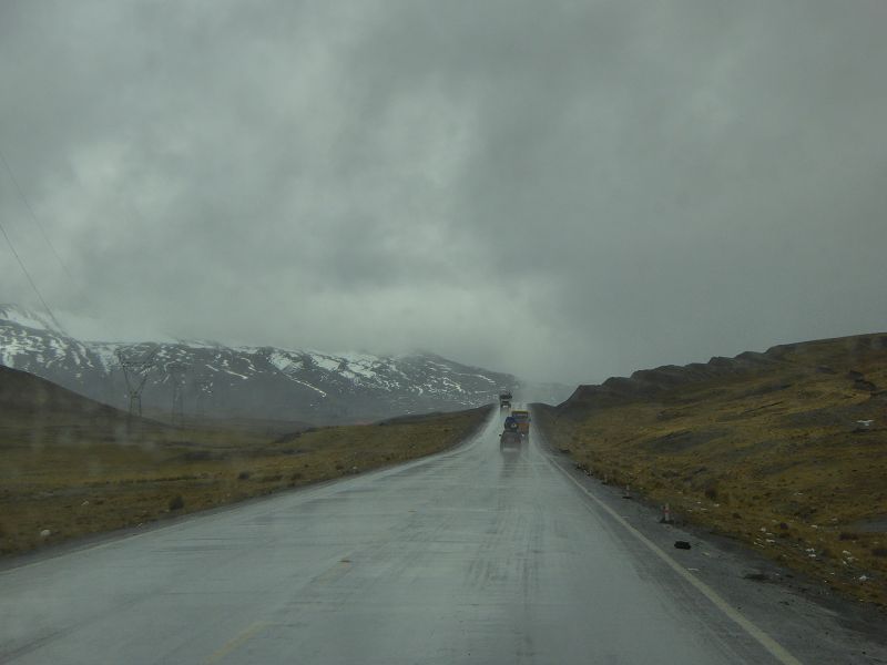
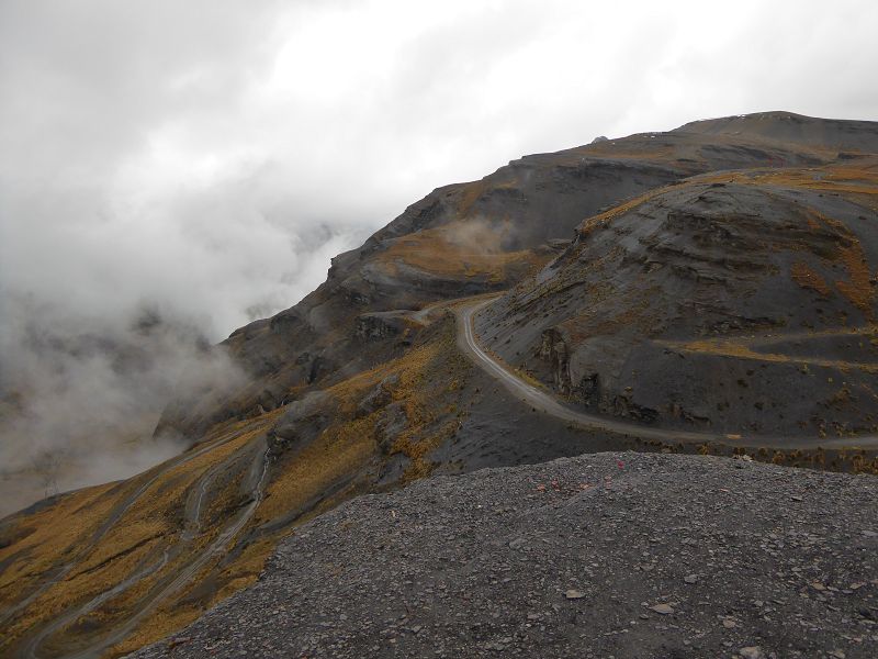
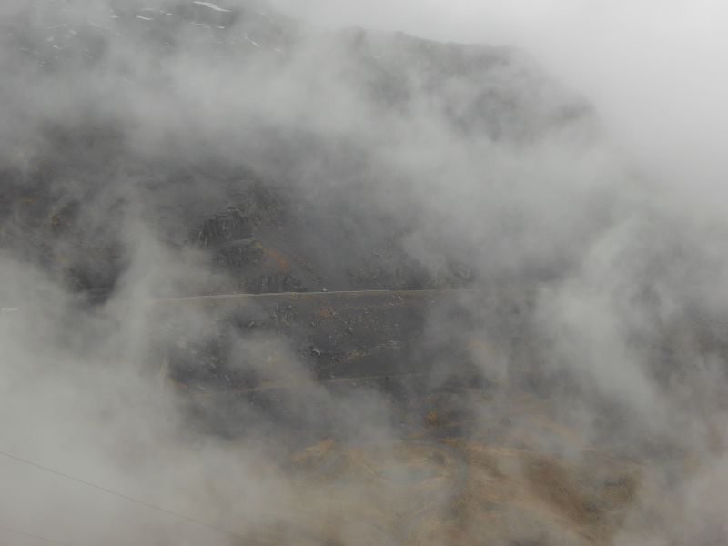
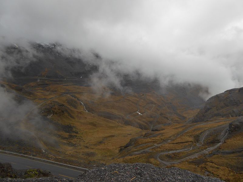
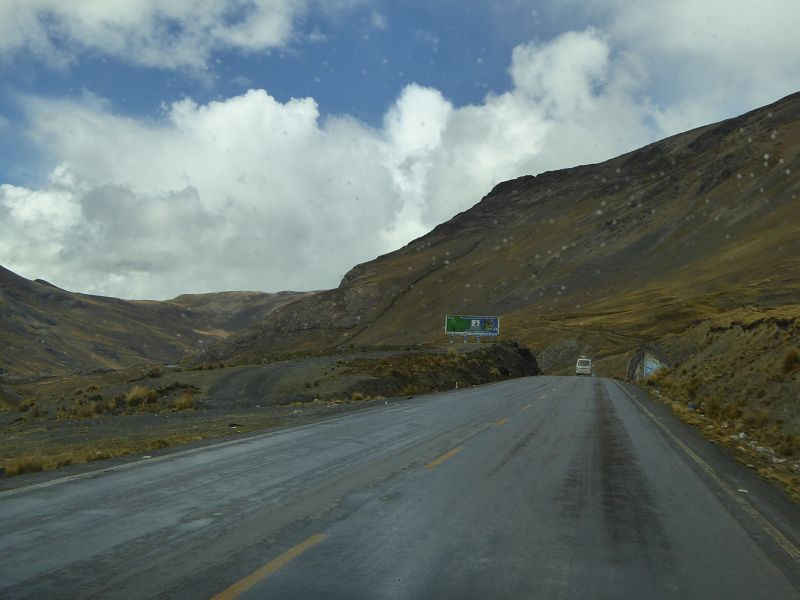
Treacherous Terrain:
- The road is known for its
narrow, unpaved
stretches that wind around cliffs and steep drop-offs.
It is incredibly steep in places, and its challenging terrain
makes driving here particularly difficult, especially during
rainy seasons
or at night.
- The road is
unpaved for
large sections, and conditions can vary greatly, especially in
the high-altitude areas where the air is thin and the weather
can change rapidly. Drivers must be prepared for
muddy or
dusty
conditions depending on the season.
-
Dangerous Reputation:
- The name
Carretera del Diablo
comes from the danger and difficulty of the road. For centuries,
travelers have feared the treacherous and unpredictable
conditions, giving rise to the highway's menacing reputation.
- Because of the
sharp curves,
steep inclines,
and the fact that some sections of the road
cliff-hang
along sheer rock faces, it’s often referred to as one of the
most dangerous roads in Peru.
-
Spectacular Views:
- Despite the danger, the
Carretera del Diablo
offers stunning views of the
Andean landscapes,
including snow-capped
peaks, rugged
mountains, and lush valleys. The scenic beauty makes
the journey worthwhile for adventurous travelers.
- The road also passes
through remote
villages and
Andean communities, offering travelers a glimpse of
rural life in Peru and the opportunity to experience traditional
culture and
customs in
the highlands.
-
Alternative Routes:
- While the
Carretera del Diablo
is a thrilling experience for some, it is also
challenging
and difficult
for travelers who are unfamiliar with high-altitude mountain
roads. As a result, many travelers opt for alternative routes
that are more paved
and less hazardous,
particularly for buses or longer journeys.
- The
main road
between Cusco and Puno has been
modernized in
some sections to make it safer and more accessible, and there
are safer alternatives
for travelers looking to avoid the Carretera del Diablo.
-
Popular Among Adventurers:
- The Carretera del Diablo
remains a popular
route for those seeking adventure, especially
backpackers
and adventure tourists.
It is often traveled by those making their way to destinations
like Lake Titicaca,
Puno, or
other points along the
Peruvian altiplano.
- Motorcyclists and
thrill-seekers often include it in their route to experience the
exhilaration of navigating the twists and turns of the road.
-
Safety Tips:
- If you plan to drive or
travel along the Carretera del Diablo, it’s essential to be
prepared. Some of the most important
safety tips
include:
- Ensure your
vehicle
is in good working condition, particularly the brakes and
tires.
-
Check the weather
forecast before traveling to avoid being caught in
poor conditions.
- Travel with a
local guide
or someone familiar with the road to help navigate safely.
- Keep in mind the
altitude
(over 3,800 meters / 12,500 feet) and take time to
acclimatize
to avoid altitude sickness.
- Be prepared for the
unpredictable, especially if traveling during the
rainy season
(November to April), as
mudslides
can occur.
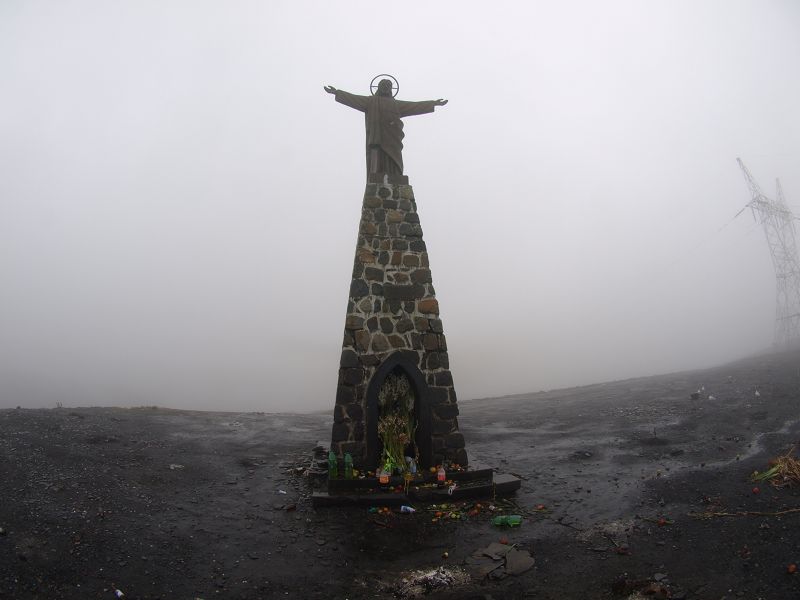
In Summary:
The
Carretera del Diablo
is a perilous but captivating route through the
Andes that offers
unforgettable views and an adrenaline-filled journey. While it’s not for
the faint of heart, it draws those with a taste for adventure who are
eager to experience the rugged
beauty and
challenging terrain of southern Peru. Whether you're planning
to drive or just curious about this infamous highway, it remains one of
the most iconic and dangerous roads in the world.
|
The
Yungas is a geographical
region located in the Andean
foothills of South
America, specifically in
Bolivia and
Peru, although the term
is most commonly associated with Bolivia. It refers to a transition zone
between the high-altitude Andes
Mountains and the
lowland tropical regions of the
Amazon Basin.
Key Features of the Yungas
Region:
-
Location:
- The
Yungas region
is found along the eastern slopes of the Andes, stretching from
the Andean highlands
down to the Amazon Basin.
- It is particularly prominent
in Bolivia,
where it includes the
Yungas of La Paz, which lies to the
northeast of
the capital, La Paz.
- The Yungas is often divided
into two parts: the
upper Yungas (closer to the Andes) and the
lower Yungas
(which slopes down toward the Amazon rainforest).
-
Climate and Ecosystems:
- The
Yungas is known
for its tropical climate,
which is characterized by
high humidity
and moderate
temperatures due to its altitude (typically between
1,000 and 3,000 meters
above sea level).
- The region has
lush forests
and a rich biodiversity, with a mix of
tropical plants,
trees, and
wildlife. It
is considered an important ecological area due to its
high level of species
diversity.
- The
upper Yungas
is characterized by cloud forests, while the
lower Yungas
transitions into the
Amazon basin, with dense
rainforests
and rivers.
-
Agriculture:
- The Yungas is known for
its fertile soil,
and it is a major agricultural area in Bolivia and Peru. Common
crops grown in the region include
coca (from
which cocaine
is derived), as well as
coffee,
citrus fruits,
bananas,
cacao, and
coca leaves.
- The area is also
significant for the
production of coca, which is a key element in both the
local economy and, unfortunately, in the global drug trade.
-
Historical and Cultural
Significance:
- The Yungas has been
inhabited by indigenous people for centuries, particularly
groups like the Aymara,
Quechua, and
Tupi. These
communities traditionally farmed the land and lived in harmony
with the forest.
- There are also remnants of
pre-Columbian
civilizations in the region, though much of the area
was less populated compared to the highlands or major cities of
the Andes.
-
Tourism and Travel:
- The Yungas is a popular
destination for
eco-tourism,
hiking, and
adventure travel. Many visitors are drawn to the
natural beauty of the region, its biodiversity, and the chance
to explore unique ecosystems.
-
Death Road (Yungas
Road): One of the most famous roads in the region is
the North Yungas Road,
also known as Death
Road, which runs between
La Paz and
Coroico. The
road is infamous for its
dangerous and winding paths down the mountainside. It
was once considered one of the most dangerous roads in the
world, with steep cliffs and frequent fog and rain making it
treacherous. However, the road has now been bypassed by a newer,
safer route, and Death
Road has become a popular
tourist attraction
for those seeking an adrenaline-filled experience.
-
Flora and Fauna:
- The Yungas is home to
diverse wildlife
and is a critical habitat for a variety of species, including
monkeys,
jaguars,
pumas,
tapirs, and a
wide range of bird
species like
toucan and
macaws.
- The
cloud forests
of the upper Yungas
are home to many species of
orchids,
ferns, and
other plants that are adapted to the humid environment.
-
Infrastructure:
- The
Yungas is not
as heavily developed as other regions in Bolivia or Peru, but
there are some towns and villages in the area, including
Corico (in
Bolivia) and Chulumani,
which are accessible by road and attract visitors for their
natural beauty and traditional way of life.
- While the
North Yungas Road
(Death Road) was historically the only road connecting the
Yungas to La Paz,
there is now a new highway that bypasses the dangerous route,
making travel safer for both locals and tourists.
-
Challenges and
Environmental Issues:
-
Deforestation
is a major issue in the lower Yungas, as the expansion of
agriculture
and illegal logging threaten the rainforest. The region has also
seen increased coca
cultivation due to its high demand for producing
cocaine.
- The effects of
climate change
have also become a concern, as changing weather patterns can
disrupt agricultural production and threaten the delicate
balance of ecosystems.
Summary:
The
Yungas is a
fascinating region, rich in natural beauty, cultural history, and
biodiversity. Its unique mix of
Andean highlands and
Amazon basin
ecosystems makes it a critical area for conservation and ecological
studies. It offers opportunities for
adventure tourism,
trekking, and
eco-tourism, with its
lush forests, remote villages, and rugged landscapes. However, the
region faces challenges related to
sustainability,
deforestation, and
the illegal drug trade,
which affect both the environment and the local communities.
|
 Safaris
Bergsteigen
Wandern
Inselwandern Weltweit
Safaris
Bergsteigen
Wandern
Inselwandern Weltweit
 Chronologie
Inselwandern
Chronologie
Inselwandern Europa
Inselwandern
Europa
Inselwandern
 Städtewandern
 Paintings
 Dirk Rauschenbach